


Descrizione di SailGrib Weather Routing Free
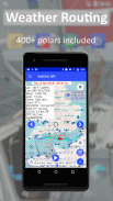
SailGrib WR is an easy to use full-fledged marine navigation app with a very sophisticated and unique weather routing module.
It is designed for recreational cruisers or demanding racers.
It can calculate the fastest sailing route to your destination along a route with waypoints.
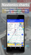
SailGrib WR is the first app to use the Android Navionics sdk that allows you to display your Navionics Boating charts directly in the app without any additional cost.
The app has earned the following distinctions :
- designed for Iridium GO! and Approved by Iridium - january 2015
- Voiles et Voiliers - use it while cruising or racing - November 2014
- Yachting World - "impressive" - July 2014
- Transatlantic race The Cape - Rio 2014 - The Sun Fast 3200 Yolo winner in class 2
- Fastnet 2015 - The JPK1010 Nautistock.com winner in IRC3
- Tour de Corse 2016 - The Sun Fast 3200 Hokua winner in IRC4 and 3rd in IRC Overall
- Spi Ouest France 2017 - The JPK 1080 LSResa winner in IRC double-handed
It now includes:
- free download of all NOAA marine raster charts
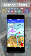
- in app purchase of marine raster charts atlases derived from UKHO, SHOM and NOAA marine charts
- a WiFi NMEA interface
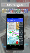
- an AIS module
- a navigation panel
- a instrument panel
- the option to load custom charts
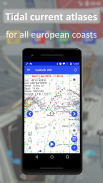
- a full set of atlases of tidal currents for all the European coasts. A SailGrib WR exclusivity
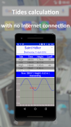
- a tide module which calculates and displays tides level predictions around the world
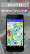
- the NOAA models:
- GFS 0.25°, 0.50° and 1.00°
- NAM and NAM Nest for the continental US
- WW3 global waves
- the Météo France models:
- Arpege - Global 0.5°
- Arpege - Europe - High Resolution 0.1°
- Arome - France - Ultra High Resolution 0.025°
- the oceanic and coastal current models from Mercator Ocean.
- a virtual regatta option to help you win games.
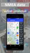
In SailGrib WR, you can specify for your weather routing amongst other parameters:
- the wind grib file: SailGrib WR includes the regular SailGrib features.
- the start, the destination points and intermediary waypoints
- the departure date and time,
- the speed polar file of your boat. SailGrib WR uses regular Maxsea polar files (.pol extension)
SailGrib WR includes a set of more than 300 polar files for different sailboats.
- wind limits up and downwind
- minimum upwind angle for comfort while cruising
- night efficiency loss for cruising
- mixed routing: use your engine if you are too slow sailing.
- the current
The Free version is limited to:
– 2 days of GFS 0.50° forecast
– 1 day of tidal forecast
– 50 NM routings
– no atlas of tidal currents
– no navigation panel
– no displaying of Navionics charts
You can subscribe to the Premium option for 1 month, 1 year or for life to get all these functionalities.
Important note:
Grib files are computer-generated forecast files which are sent without review, and are offered on an as-is basis. There is no assurance that the data is accurate or correct. By using such data, you acknowledge and agree to these limitations.
The weather routing module is for planning purpose only.
The maps usedeither in navigation or by the weather routing algorithm might be very coarse and for example might not include all the islands.
The Location used by the navigation module migt be inacurate.
By using these maps, these data and this algorithm you agree to these limitations and assume all the responsibility for their use.
SailGrib WR è un'applicazione di navigazione marina a tutti gli effetti facile da usare con un modulo di routing meteo molto sofisticato e unico.
È progettato per gli incrociatori da diporto o per i piloti esigenti.
Può calcolare il percorso di navigazione più veloce verso la tua destinazione lungo un percorso con waypoint.
SailGrib WR è la prima app ad utilizzare il sdk Android Navionics che consente di visualizzare le tue carte nautiche Navionics direttamente nell'app senza alcun costo aggiuntivo.
L'app ha ottenuto le seguenti distinzioni:
- Ideato per Iridium GO! e Approvato da Iridium - gennaio 2015
- Voiles et Voiliers: utilizzalo durante le crociere o le corse - novembre 2014
- Yachting World - "impressionante" - luglio 2014
- Gara transatlantica The Cape - Rio 2014 - Il vincitore del Sun Fast 3200 Yolo in classe 2
- Fastnet 2015 - Il vincitore del JPK1010 Nautistock.com in IRC3
- Tour de Corse 2016 - Il vincitore Sun Fast 3200 Hokua in IRC4 e 3 ° in IRC Overall
- Spi Ouest France 2017 - Il vincitore di JPR 1080 LSResa in IRC in due mani
Ora include:
- Download gratuito di tutte le carte nautiche raster di NOAA
- in acquisto di app di atlanti di carte nautiche raster derivate da carte nautiche UKHO, SHOM e NOAA
- un'interfaccia WiFi NMEA
- un modulo AIS
- un pannello di navigazione
- un cruscotto
- l'opzione per caricare grafici personalizzati
- una serie completa di atlanti delle correnti di marea per tutte le coste europee. Un'esclusività SailGrib WR
- Un modulo di marea che calcola e visualizza le previsioni di livello delle maree in tutto il mondo
- i modelli NOAA:
- GFS 0,25 °, 0,50 ° e 1,00 °
- NAM e NAM Nest per gli Stati Uniti continentali
- Onde globali WW3
- i modelli Météo France:
- Arpege - Global 0.5 °
- Arpege - Europa - Alta risoluzione 0.1 °
- Arome - Francia - Altissima risoluzione 0.025 °
- i modelli attuali oceanici e costieri di Mercator Ocean.
- Un'opzione di regata virtuale per aiutarti a vincere le partite.
In SailGrib WR, puoi specificare il tuo percorso meteo tra altri parametri:
- il file wind grib: SailGrib WR include le normali funzioni di SailGrib.
- l'inizio, i punti di destinazione e i waypoint intermedi
- la data e l'ora di partenza,
- il file polare velocità della tua barca. SailGrib WR utilizza file polari Maxsea regolari (estensione .pol)
SailGrib WR include un set di oltre 300 file polari per diverse barche a vela.
- Il vento limita e sottovento
- Angolo minimo di ribaltamento per il comfort durante la crociera
- perdita di efficienza notturna per la crociera
- Instradamento misto: usa il motore se navighi troppo lentamente.
- il corrente
La versione gratuita è limitata a:
- 2 giorni di previsione GFS 0,50 °
- 1 giorno di previsione delle maree
- 50 rotte NM
- nessun atlante di correnti di marea
- nessun pannello di navigazione
- Nessuna visualizzazione delle carte Navionics
Puoi sottoscrivere l'opzione Premium per 1 mese, 1 anno o per la vita per ottenere tutte queste funzionalità.
Nota importante:
I file Grib sono file di previsione generati dal computer che vengono inviati senza revisione e vengono offerti su base "as-is". Non vi è alcuna garanzia che i dati siano accurati o corretti. Utilizzando tali dati, riconosci e accetti queste limitazioni.
Il modulo di routing meteo è solo a scopo di pianificazione.
Le mappe utilizzate nella navigazione o dall'algoritmo di routing meteorologico potrebbero essere molto grossolane e, ad esempio, potrebbero non includere tutte le isole.
La posizione utilizzata dal modulo di navigazione può essere imprecisa.
Utilizzando queste mappe, questi dati e questo algoritmo accettate queste limitazioni e assumete tutte le responsabilità per il loro uso.
SailGrib Weather Routing Free - Versione 7.9
(23-02-2024)SailGrib Weather Routing Free - Informazioni APK
Versione APK: 7.9Pacchetto: com.sailgrib_wrApp nella stessa categoria
Potrebbe piacerti anche...


